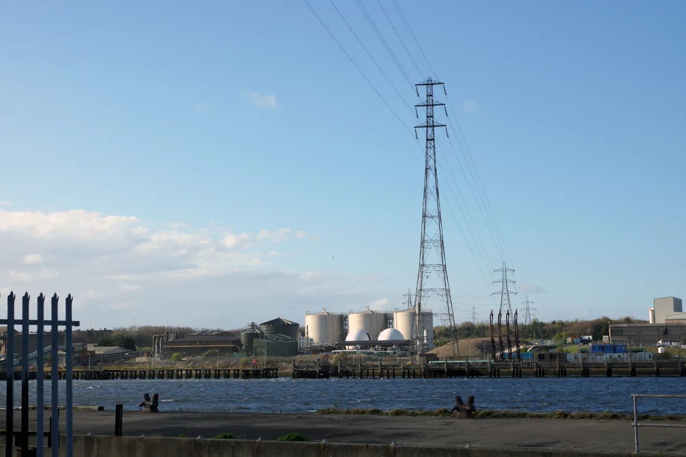

National Grid plans a 1.6km power tunnel under the Tyne from Howdon to Jarrow, so the tall pylons can come down. Work would start around 2028 and end by 2034.
The two tall pylons that carry power lines over the Tyne between Howdon and Jarrow would be taken down under National Grid plans. The cables would run through a 1.6km tunnel bored under the river instead.
The company has asked North Tyneside Council to decide whether the scheme needs a full environmental impact assessment. The request, reference 26/01469/SCREIA, was validated on Monday 19 October. The address on the file is the former Esso terminal on Howdon Road, about four miles south-west of Whitley Bay.
The screening report on the file was written for National Grid by the engineering firm WSP. It sets out what would be built, when, and how much traffic it would bring.
Why the pylons are in the way
The line is a 275kV double circuit that crosses the river at towers known as ZZA064 and ZZA065. It was put up in the 1960s, the report says, when it caused river users no trouble.
Ships now carry far taller loads. The report says the line has become “a hindrance to large vessels/cargo sailing along the River Tyne, specifically jacket foundations produced for the offshore wind industry.” Jackets are the steel lattice bases that offshore wind turbines stand on.
National Grid has taken sections of the line down to let tall loads through on two occasions in the past, according to the report. It says that is no longer possible, because of the risk to electricity supply and the cost of switching off a double circuit.
What would be built
The report lists the main parts of the scheme:
- a tunnel about 1.6km long and 4m wide, bored under the river from north to south
- six high-voltage cables inside it, with room left for more later
- a tunnel headhouse and a cable compound of about 75m by 75m on each bank
- six new pylons, four on the North Tyneside side and two on the South Tyneside side
- about 950m of new overhead line on the north bank and 450m on the south
- removal of the existing line and towers ZZA063 to ZZA068
The northern shaft would sit east of Northumbrian Water’s Howdon treatment works. That headhouse would hold the fans that ventilate the tunnel. The southern shaft would be in a Port of Tyne car park in Jarrow.
The tunnel is designed to last 100 to 120 years. Once built, the sites would be unmanned, with yearly inspections and maintenance every ten years.
When it would happen
The report gives these timings:
- about 18 months for design and consents
- about three and a half years of building work
- a start “around 2028”, with completion by 2033 or 2034
The old pylons over the river would only come down at the end, once the new cables were connected and working.
Twice as much spoil as first thought
National Grid first asked for a screening opinion in 2025. This is a fresh request, and the report says why. The design has changed, and the estimate of earth and rock to be dug out has risen from about 18,850 cubic metres to 34,300 cubic metres. That is an increase of about 82%.
The new figures break down like this:
| Part of the works | Spoil (cubic metres) | Removed from |
|---|---|---|
| North shaft, Hayhole Road | 7,500 | North bank |
| Tunnel bore | 20,500 | North bank |
| South shaft, Jarrow | 6,300 | South bank |
The report says about 2,000 cubic metres of it may be contaminated. Because the changes are all on the north side, National Grid has asked only North Tyneside for an updated opinion this time.
Lorries on Howdon Road
Most of the spoil would leave by lorry from the Howdon side. The report assumes 20-tonne tippers and works out the loads:
- 750 loads from the north shaft over 16 weeks
- 2,050 loads from the tunnel over 31 weeks
- 630 loads from the south shaft over 18 weeks
At the busiest point, the north site would see 269 vehicle movements a day. That is 69 lorry movements and 200 movements by workers’ vehicles, for a workforce of up to 150 a day. Construction traffic would reach the site from the A19 southbound, along the A193, and turn in and out of a new left-in, left-out junction on the A187 Howdon Road.
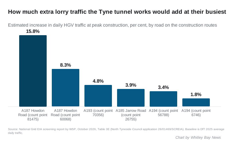
The report’s own figures put the biggest effect on Howdon Road. At one traffic count point there, lorry traffic would rise by 15.8% at the peak; at the other, by 8.3%. Total traffic on the same stretches would rise by about 2%.
The report accepts that there is “potential for significant impacts” on the A187 Howdon Road and the A185 Jarrow Road while the work goes on. Its overall view is that the effects are not significant, because the roads are dual carriageways or run through industrial areas. It adds that taking the spoil away by boat is being looked at, which “would significantly reduce” the lorry traffic if it went ahead.
Wildlife and heritage
The site covers about 49 hectares. Howdon Wetlands and the river itself are local wildlife sites inside the boundary, as are the Jarrow Slake mudflats on the south bank. On the Jarrow side, two existing towers stand in St Paul’s Conservation Area, near the ruins of Jarrow Monastery.
The report promises further work before any planning application, including:
- a landscape and visual impact assessment
- a construction traffic management plan
- a construction noise and vibration assessment, including noise under water
- a habitats assessment covering the Northumbria Coast protected sites
What the council’s advisers have said so far
Two responses are on the file. The Tyne and Wear archaeology officer agrees that significant effects on buried remains are unlikely. A desk study, and digging if needed, would come first.
The council’s flood risk team agrees the scheme is unlikely to cause significant flood risk “subject to appropriate design”. It asked for a full flood risk assessment and a drainage plan for the tunnel, shafts and headhouses, including pumping and what happens if the pumps fail.
What it means for you
- No planning application yet. This request only asks whether a full environmental impact assessment is needed. National Grid’s report argues it is not, and says the company will carry out a voluntary assessment anyway.
- The tunnel itself may not need planning permission. If the council agrees no full assessment is needed, National Grid says it will bore the tunnel under its permitted development rights. The headhouses, compounds and tower removal would still need a planning application to North Tyneside.
- The new pylons need government consent. The overhead line work falls under Section 37 of the Electricity Act 1989, decided by the Energy Secretary rather than the council.
- Cyclists and walkers. The Hadrian’s Cycleway (route 72) and the River Tyne Trail pass the site beside Howdon Road. Any diversions would be set out in the traffic plan, which has not been published.
- When you can have your say. The planning application is the point to comment on the design, the traffic and the lorry routes. We will report it when it is lodged.
Councils normally have three weeks to give a screening opinion under regulation 6 of the 2017 EIA regulations, unless the applicant agrees to more time. You can follow the file on the council’s planning register, and other schemes around the borough on our planning news page.
Have your say